|
 |
Click on a thumbnail to zoom in.
|
|
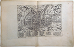 |
Forlani, Paolo, Parise [in banner, top center] and Il Vero disegno et ritrato della Citta di Parigi sedia regale della francia…In Venetia L’Anno M.D.LXVII. [bottom left]. Venice, 1567 [1569]. 7.5 x 10.25″ (19 x 26 cm). Copperplate engraving. Uncolored. $3,500.
This is the ninth plan of Paris listed by Jean Boutier in his comprehensive compilation of the history of the plans of Paris. Boutier, Les Plans de Paris, Bibliothèque nationale de France, 2002. It was engraved by Paolo Forlani and first published by him in Venice in 1567. In 1569 Bolognini Zaltieri, for whom Forlani often worked, republished the map in Giulio Ballino’s De' disegni delle più illustri città ...., from which this map comes. Two pages of text are printed on the back of the map: one with 34 lines, the other with 29 lines, which identifies it as coming from the Venetian edition of 1569.
Below the birds-eye view plan is a table listing forty-three buildings. At the top left is the arms of France with a crown held by two angels. At the top right held by an angel is the arms of the city of Paris, without the fleur de lys. The map is oriented with north to the left. A fascinating view of Renaissance Paris. A few smudges in the margins, else fine. Boutier, 9Ba
|
|
|
|
|
| |
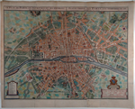
Bodenehr, Gabriel the elder, Paris die Haupt Stadt in Franckreich. Augsburg, [after 1716, about 1720]. 5.75 x 7.5″ (14.5 x 19 cm) the map only, with panels of text on each side. Copperplate engraving. Modern wash color. $295.
Gabriel Bodenehr was an engraver and printseller in Augsburg who took the credit for both making and engraving this plan of Paris (“G. Bodenehr fec. et excudit Aug. Vindelicorum”, below the map). He, however, did no such thing but instead purchased the printing plate from the Stridbecks who had published it soon after de Fer published his own plan of Paris in 1701, the Stridbeck plan being a copy of de Fer's in miniature. Oh, what fertile ground for a copyright lawyer! It is, nevertheless, a charming, small plan, beautifully colored. Fine condition. Boutier 149 |
 |
Delisle, Guillaume, Le Plan de Paris, ses Faubourgs et ses Environs. Published by Jean Covens and Corneille Mortier, Amsterdam, about 1720 [1730-1757]. 22 x 29.25″ (56 x 74.5 cm). Copperplate engraving. Fine modern wash color. $2,100.
The great Guillaume Delisle based his plan of Paris on de Fer’s of 1707 and he was given credit for it in the early printings of this plate but by the time Covens and Mortier printed it de Fer’s named had been rubbed off the plate and only Delisle and C&M’s names appear on it. It was published in several editions of Delisle’s Atlas nouveau issued by C&M between 1730 and 1757. This map is from one of those. North is to the left. Two sheets printed from two plates which did not join correctly (thus, all copies of this map appear mis-joined). Rebacked and folds reinforced, a few light stains in the margins, a repaired tear in the left margin just entering the map. Boutier 193. |
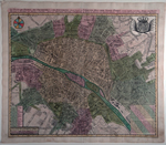 |
Seutter, Matthäus the elder, Le Plan de Paris, ses Faubourgs et ses Environs divisé suivant ses Meridiens et Parallels par Minutes et Secondes. Gravé par Matthieu Seutter, à Augsboug. Title repeated in German. Augsburg, [1720-1724, without the line added bottom right in 1731 signifying Seutter as Imperial Geographer]. 18.5 x 22.5″ (47.5 x 57 cm). Copperplate engraving. Original wash color. $1,550.
Seutter was apprenticed to the well-known mapmaker J. B. Homann and went on to become his primary competitor. He and his family were major map publishers yet they produced only about forty original maps, the others being copies. This map is oriented to the meridian at the Paris Observatory and, according to Boutier, it is copied not from the first map to do so (Delisle’s of 1716) but the second, de Fer’s from the following year. Whatever, it is a handsome, desirable map with fine, bright original color.
A few stains and thumbsoiling in the margins, printer’s creases in left margin, else fine. Boutier 194A. |
|
|
© 2009-2014 Susan Benjamin Rare Prints & Maps. All Rights Reserved. |
|
|
|
|